|
AidenP
12/12/2014 03:46:14 am
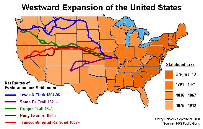
A map of important parts of westward expansion! This map shows the paths of important people and things that were involved in westward expansion. It shows the trails and names of things down in the key, too. The blue is Lewis and Clark, who helped president Thomas Jefferson explore the west. The purple shows the Santa Fe route. Green is the Oregon Trail, a huge part of westward expansion too because it is what many people used to get their free land in Oregon. Finally, the red ones are train routes. In the background it looks like the darker the shade of orange, the earlier it was found, also as shown in the key.
Zach
12/12/2014 04:10:29 am
Great job on your thoughts! I really liked how you explained everything that was in the picture. Like the Lewis and Clark trail, the Santa Fe route, the Oregon Trail, etc. I also saw that you explained a little about the Statehood Eras and i thought that was awesome! Did you happen to notice that the top states from Michigan over to Washington weren't explored until after the states below them were. The funny thing is that some states were right below them!
Dawson
12/12/2014 04:24:05 am
AidenP, you did an excellent job of explaining that you thought of the routes on the map. Wow you did a great job!
jaidyn
12/12/2014 04:01:36 am
I noticed that the Oregon trail was on this map so that means that this was taken after the Louisianan purchase. think that this was a map used to show the important routs after the Louisianan purchase. i realized that the Lewis and Clark trail starts in the Mississippi river then all the other connect off of Lewis and Clark's trail.I noticed that the Oregon trail was on this map so that means that this was taken after the Louisianan purchase. think that this was a map used to show the important routs after the Louisianan purchase. i realized that the Lewis and Clark trail starts in the Mississippi river then all the other connect off of Lewis and Clark's trail.
AidenP
12/12/2014 04:22:15 am
Great inferring Jaidyn! I totally agree that this stuff is true, too.Those are some great ideas! Did you check out those Statehood eras on the right? That would be a great idea to post too. Overall, great comment, just capitalize you I's!
Jenna
12/12/2014 04:06:54 am
I think these are trails that people created around the time of the westward expansion. I think this because some of the trails like the Lewis and Clark trail the Oregon Trail and the Santa Fe Trail were created around the time of the westward expansion. I think this map took place during the westward expansion because all of the trails are coming from the east going west. This relates to the westward expansion by all of the trails that are on the map being followed around the time of the westward expansion.
Deveshi
12/19/2014 10:17:14 am
Good job Jenna! I agree with you that the map relates to the Westward Expansion because of the trails. Did you also notice the Statehood Eras? Otherwise that is a good comment. 8/24/2019 02:11:21 pm
May I print this map for a library display that I am assembling for our county library in Jacksonville, FL? The display is to promote reading and interest in historical topics for children. I was an elected school board member in Bakersfield, Ca for 16 years before retiring. I am a volunteer and Regent of the Jean Ribault Chapter of DAR. We promote patriotism, education and historic preservation. I am in my third year of monthly library displays on historical subjects. Leave a Reply. |
Room 506Here at Elmwood Elementary we share our thinking and ideas to improve our learning. Archives
November 2016
Categories |
 RSS Feed
